|
The
Karakoram Highway known as K.K.H., has been cut through
the highest and the mightiest mountains of the world, that
is, the Himalayas and the Karakorams. This Highway connects
Pakistan with the People's Republic of China via Khunjrab
pass (16,200 feet above sea level) beyond which lies the sprawling
Xinjiang province of our friendly neighbour and the fabled
city of Kashgar. ft has, thus opened a passage through the
isolated mountainous regions which remained a cultural backyard
of humanity for millennia. This highway has been described
as the eighth wonder of the world by hundreds of travellers
and beyond any doubt, it is the marvel of modern engineering.
The brave road builders of China and Pakistan took twenty
years to complete this 774 km. long highway which has been
stretched over the hills, gorges; valleys and rivers.
It
was not easy to conceive and to execute such a Herculean project
particularly in such a monstrous region. No wonder it had
been considered impossible by some of the world's biggest
consortiums. In fact the construction of the highway involved
about thirty million cubic yards of rock blasting and earthwork,
over eight thousand tons of explosives and eighty thousand
tons of cement and so many other materials and that too in
thousands of tons. Approximately fifteen thousand men of the
Pakistan Army and the Chinese workers, working shoulder to
shoulder, cut through one of the most difficult terrains in
the world and toiled under the most trying conditions. It
is believed that more than five hundred persons, that is,
about one person per mile, lost their lives in the road building
process.
The
Highway itself is the greatest memorial to those martyrs who
sacrificed their lives during blasting, rockfalls, landslides,
earthquakes and avalanches. And humanity ows a deep debt of
gratitude to all those who lost their lives during the road
building. Their success, however, has opened a new chapter
in the world's history as this road will be used by generations
after generations of the human beings not only to learn about
these high mountains and the people who live there in the
scattered valleys but also to draw together, in a common pursuit
of peaceful trade, as it was once done with great difficulty
through the famous Silk Route.
For
many centuries caravans braved these tortuous mountains treading
precariously along the goat tracks and narrow paths sometimes
providing short cuts between the great caravan towns of the
Central Asian and rich markets of the subcontinent. However,
the trails were too hazardous, angry rivers too horrifying
to contemplate, storms and avalanches caused even the most
intrepid to quail on the high passes and in the desolate gorges.
It
was in fact, the great Han empire of China that extended its
influence towards this part of the world and controlled roads
leading through it. The most important item of trade, in which
China was interested at that time was the export of Chinese
silk and hence the popularity of the name. The Silk Route,
which traversed the Tarim basin in its westward extension
through
Central Asia to meet the markets in the Mediterranean coast.
From second century B.C. to about fifth century A.D. the trade
continued to flow. Thereafter the rise of the Hsiung-nu dislocated
trade connections and the name of Silk Route survived in legendary
tales only.
The
ancient Silk Route started at Ch'angan (modern Si-gan-fu,
former capital of the province of Shen-si) on the north-western
borders of China and skirted the Gobi desert westward to Dun-huang,
where it bifurcated into two - one passing the northern edge
of the Tarim basin through the world famous Turfan treasures,
Aksu and on to Kashgar; and the second followed the southern
edge at the foot of Kun Lun and reached Khotan, Yarkand and
on to Kashgar. The journey westward was either over the north
of Pamir towards Samarkand or across the smaller valleys south
of it through Wakhan, Badakhshan and onwards to Bactria north
of the Hindukush in the valleys of the Oxus. It is the centres
on the southern route that threw down paths around the FIun
Lun towards Karakorum region, opening a passage for trade
to the Indo-Gangetic plains. From time to time the passage
has varied, depending upon its starting point in Khotan, Qargalik
or Yarkand, the eastern-most being the Khotan route across
the upper valley of Yarkand river over to Kun Lun. On the
South it crossed the Muztag river and after passing through
Shimshal reached the main channel of Hunza river. But a route
from Yarkand proper would follow its tributary of Tashkurgan
river and reach the town of that name and branch off either
towards Wakhan or towards Khunjrab. It is the Wakhan route
that can be reached directly from Gilgit, Chilas or Chitral
over high passes.
The
following two quotations of the two world famous ancient travellers,
that is Mr.Hiuen Tsang and Mr. Sung-Yung-Yun throw sufficient
light on the problems of the old Silk Route. Hiuen Tsang described
his journey to Swat in the following words:
"The
road was difficult and broken, with steep crags and precipices
in the way. The mountain side is simply a stone wall standing
up 10,000 feet. Looking down, the sight is confused and on
going forward there is no sure foothold.
Below
is a river called Sint-uho (Jndus). In old days men bored
through the rocks to make a way, and spread out side-ladders,
of which there are seven hundred (steps) in all to pass. Having
passed the ladders, we proceeded by a hanging rope-Bridge
and crossed the river. The two sides of the river are something
less than 80 paces apart."
San-Yan
described as under:
"The
mountains here are as lofty and the gorges deep as ever. The
king of the country has built a town, where he resides, for
the sake of being in the mountains. The people of the country
dress handsomely, only they use some leathern garments. The
land is extremely ëold so much so, that the people occupy
the caves of the mountains as dwelling places, and the driving
wind and snow often compel both men and beasts to herd together.
To the south of this country are the snowy mountains, which,
in the morning and evening vapours, rise up like gem-spires".
From
the description it appears to be the present Misgar area,
where caves are still seen and used for living purposes. If
this identification is correct, Sung-Yun must have crossed
over the Mintaka pass.
The
ancient approach was across the Kilk Mintaka Pass over to
the opening of Misgar and onwards to Hunza. Mintaka Pass opened
up in the Chinese empire on the east and Tsarist Russia on
the north-west. The present opening at Khunjrab provides an
easy access to China's potential trade influence down to the
Arabian sea and onwards to the free world for the first time
in history.
The
modern K.K.H. which may also be called as a substitute of
the ancient silk
route begins from Islamabad and passes through, Rawalpindi
- Taxila -
Hassan Abdal - Haripur - Abbottabad - Batgram -Besham Qila
- Pattan -
Chilas - Jaglot - Gilgit - Hunza - Gulmit - Passu - Sust and
enters China at
Khunjrab.
Approximate
distances and travelling on the K.K.H. by light transport
are given below, but much would depend on the season and the
driving skill of the driver.
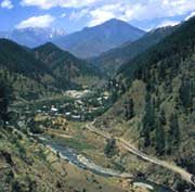
The
K.K.H. passes through a scenic wonderland. The landscape
changes almost after every mile. Along the road there are
scores of sites and scenes which deserve careful study and
observation and there are things which cannot be described
in words alone. Above all a drive from Jslamabad to Khunjrab
is a rare and life long experience which nobody can forget
after going through it once.
Maintenance
of road, however, is a major problem because Karakorams are
active even today. There is a continual disintegration in
the higher regions because of the interactions of several
factors including the effects of climate variations and the
forces of gravity,rain, snow,ice, mud floods etc. all play
key roles in the general destruction of these mountain areas.
When parts of the valley walls break away, or when the streams
undercut these steepest
precipices
on earth then gravity causes small and large fragments, in
single pieces or in thunderous avalanches, to descend at frightening
speeds to the floor of the valley. Several parts of the road,
and even villages are, either washed away or buried under
several thousand tons of mud. A few years ago the Batura Glacier,
just a few kilometres from the beautiful Gulmit, quietly advanced
and with its blunt snout nudged away the towers of a strong
bridge toppling it into the Hunza river. It has not been found
possible to rebuild the bridge which causes great problems
during the summer season when the flow of water increases
due to snow-melting.
Found
in this region, and perhaps nowhere else in the world, is
the snow leopard. Also, Marco Polo sheep, the Markhor and
Thar (a wild goat), the Bhural (a sheep), and Deer were common,
but now they are extremely rare. One of the several rare species
of birds is the colourful "Ram Chakor' the ordinary Chakor,
a kind of pheasant, is also found in other parts of the country,
but the 'Ram' lives along the Karakoram Highway up to the
Chinese border. It is much bigger than the Chakor found near
Quetta, far to the southwest. Pheasants of other types also
abound--the trapogan, kalege and chir. The first of these,
the trapogan, is now almost extinct.
|